POWERED BY: SEGAL
 nuvem@segal.ubi.pt
nuvem@segal.ubi.pt
nuvem@segal.ubi.pt
NUVEM
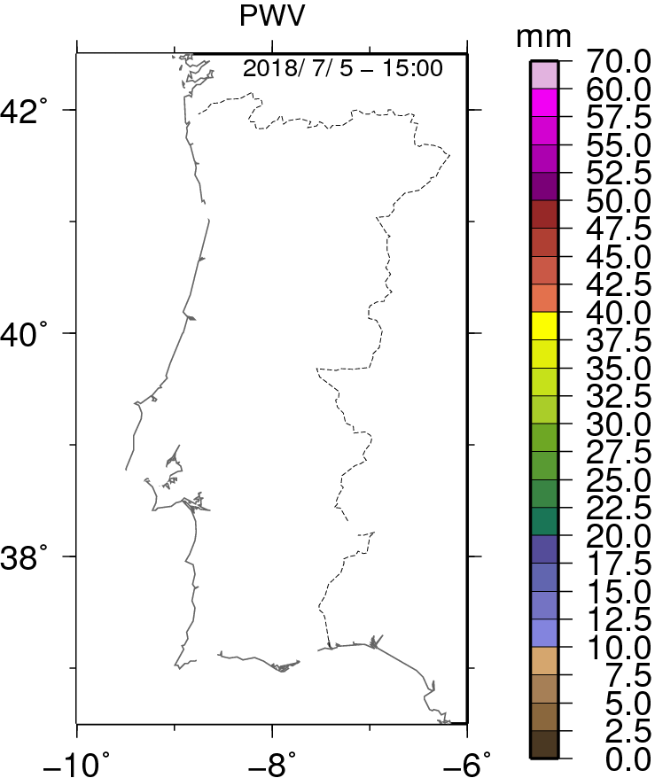
Water vapor is difficult to measure, but is of great importance for accurate modeling of the dynamics of the atmosphere, both for weather prediction and for climate applications. Nowadays, the use of information about the atmospheric water vapor content above each receiving GNSS antenna is already obtained routinely from accurate geodetic data analysis. In this respect, the application of GNSS (Global Navigation Satellite System) observations for use in very short range weather forecasting (nowcasting) has improved considerably in the last few years due to:
a) improved GNSS raw data timeliness (hourly uploads and/or real-time data streaming);
b) improved coverage (the number of ground-based stations of the GNSS networks has increased enormously in the last 5 years);
c) increased temporal resolution of tropospheric estimates.
Both atmospheric and geodetic communities will join efforts in order to operationalize the inclusion of GNSS-PWV estimates for nowcasting in Portugal, namely for the preparation of warnings of severe weather. The main reason for this has been the cost of ensuring receipt and response. To achieve such goal, the NUVEM project is divided in two major components:
a) development and implementation of methods to compute accurate estimates of PWV (Precipitable Water Vapor) in NRT (Near Real-Time);
b) integration of these estimations in the nowcasting operations done at IPMA (Portuguese Meteo Office).
 PROJECT ID
This project is financed by the Potuguese National Funding Agency for Science, Research and Technology. The project ID is: EXPL/GEO-MET/0413/2013
 EXECUTION DATES
This project started in 01/04/2014 and should be finished by 31/03/2015
 KEY WORDS
Nowcasting, GNSS, PWV, Operationalization
Dr. Rui Fernandes
SEGAL(UBI, IDL)

Dr. Pedro Viterbo
IPMA

Dr. Machiel Bos
SEGAL(UBI, IDL)

André Sá
SEGAL(UBI, IDL)

João Martins
IPMA

Hugo Valentim
SEGAL(UBI, IDL)

SEGAL (Space & Earth Geodetic Analysis Laboratory) is a collaborative scientific venture between University of Beira Interior (UBI) and Institute Geophysical Infante D. Luíz (IDL), which is physically located at Department of Computer Sciences (DI-UBI).

The Portuguese Institute of Sea and Atmosphere, IP (IPMA, IP) is the Portuguese public body responsible for research and policy meteorological and geophysics of Portugal.

The University of Beira Interior is a Portuguese institution of higher education aimed at the creation, transmission and dissemination of science and technology, knowledge and culture in all aspects and in communion with the surrounding region and the world.

The Instituto Dom Luiz is a public body integrated in the Faculty of Sciences, University of Lisbon.
New methods to Use GNSS Vapor Estimates for Meteorology of Portugal (NUVEM)
 GNSS4WEC 2014 Summer School, Varma, Bulgaria, September 2014
 H. Valentim
New methods to Use GNSS water vapor estimates for meteorology of Portugal
AGU 2014, San Francisco, December 2014
Fernandes, R.M.S., P. Viterbo, M.S. Bos, A. Sá, J. Martins, H. Valentim, J. Jones
Signature on GNSS PWV estimates of relevant storms affecting Iberia in recent years
IUGG General Assembly, IUGG-G07p-372, Prague, Czech Republic, 22 June – 2 July 2015
Fernandes RMS, Sá A, Miranda P, Bos MS, Martins J, Machado T
Aplicações de produtos de vapor de água com base em GNSS
Proceedings da APMG2015 – 9º Simpósio de Meteorologia e Geofísica da APMG, Tavira, Portugal, March 2015
Machado, T., Martins, Joao P.A., Rodrigues, Gonçalo ., Viterbo, P., Fernandes, R.M.S.,Bos, M., Valentim, H
Desenvolvimento de um produto de vapor de água integrado com base em estimativas GNSS
Proceedings da APMG2015 – 9º Simpósio de Meteorologia e Geofísica da APMG, Tavira, Portugal, March 2015
Rodrigues, G., Martins, Joao P.A., Machado, T., Viterbo, P., Fernandes, R.M.S., Bos, M., Valentim, H.
Ciclo diurno das nuvens costeiras na costa oeste da Península Ibérica e a sua relação com as circulações térmicas
Proceedings da APMG2015 – 9º Simpósio de Meteorologia e Geofísica da APMG, Tavira, Portugal, March 2015
Martins, Joao P.A., Cardoso, R., Soares, P.M.M., Trigo, Isabel., Pereira, M.B., Moreira, Nuno
A multiplatform Land Surface Temperature dataset using AATSR, SEVIRI, MTSAT and GOES-E for WACMOS-ET – algorithms and validation results
2015 EUMETSAT Meteorological Satellite conference, Toulouse, France, September 2015
Martins, Joao P.A., Pires, A., Schneider, P., Trigo, I., Jimenez, C.
The diurnalcycle of coastal cloudiness over west Iberia using the CM-SAF cloud datarecord (CLAAS) and a WRF regional climate simulation
15th EMS / 12th ECAM, Vol. 12, EMS2015-382, Sofia, Bulgaria
Martins, Joao P.A., Cardoso, Rita M., Soares, P.M.M.,. Trigo, I.,Pereira, M. B., Moreira, N., and Tomé, R.
Implementação e validação de um produto de vapor de água integrado com base em estimativas do sistema de navegação global por satélite no IPMA
Projecto de licenciatura em Meteorologia, Oceanografia e Geofísica. Orientação científica: Prof. Doutor José Castanheira (Universidade de Aveiro) e Doutor João Paulo Martins (IPMA)
Tiago Antunes Machado
Portuguese Activities related with ES1206 GNSS4SWEC, COST Meeting: GNSS4SWEC
3rd set of working group meetings and 6th Management Commitee Meeting, Wroclaw University of Environmental and Life Sciences (WUELS), Poland, 29 September – 2 October 2015
Sá, A.G.V.